I noticed this image appeared on the Highland News today. It was captured on the sonar equipment of the cruise ship, the Jacobite Queen which runs along the top half of Loch Ness. You can read the article here. Jacobite Cruises also mention it here, but currently without further detail.
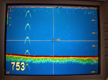
Somewhat frustratingly, no analysis is done and so one is left wondering what is being looked at. Clearly, the crew who use the sonar are not used to seeing such a trace, hence their curiosity but also their non-commitment to an interpretation. If I may add my own observations, the "753" in the bottom left presumably refers to a depth of 753 feet which places us firmly in the deepest parts of the loch, perhaps around Urquhart Bay. In fact, the maximum depth of Loch Ness is a bit of a movable feast, Wikipedia states it as 744.6 feet but another source states 786 feet. Wrongly configured sonar can record excessive depths.
I have seen several sonar traces presented by cruise operators over the years with interpretations which ranged from "the monster" to "zooplankton on the thermocline". More often than not, a simple "I don't know" is the response. Given that we don't even know if the Loch Ness Monster has a swim bladder, lungs, inflatable humps or no gas filled sacs at all, this would seem the best response.
POSTSCRIPT:
Thanks to regular reader, Jake, it has been established this sonar image was recorded in 2009 when British actress Vicki Michelle was on the Jacobite Queen. The original story is here. Sigh! We had the old Apple satellite image and now this. How about something new, media?
Thanks to regular reader, Jake, it has been established this sonar image was recorded in 2009 when British actress Vicki Michelle was on the Jacobite Queen. The original story is here. Sigh! We had the old Apple satellite image and now this. How about something new, media?